Infos :
Pictures :
Site Links :
Help of Travel :
|
|
Botswana : Climate and geography
Prepare your travel to Botswana
I. Geographical location and climate of Botswana
Location
Large pool of sand characterized by a scrubby savanna.
Northwest flowing Okavango, which permeates the sands of the desert and forms a delta of 15,000 sq km, while in the depressions of the Northeast are the large salt deserts of the Makgadikgadi Pans.
The territory is occupied almost 85% from the Kalahari, extensive semi-arid ridges of sand deposits and long sandy valleys.
Location climate
In winter (late May-August), days are clear, warm and sunny, the nights cool to very cold.
The country consists mainly of desert has fortunately, between November and March, a rainy season marked: showers and thunderstorms then bring a rain so valuable that it gave its name to the national currency (the pula).
Interim periods are rather dry.
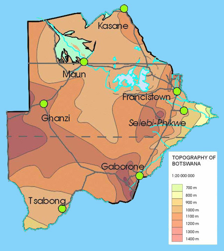
II. Relief Map of Botswana

Relief Map of Botswana
III. Temperatures in major cities of Botswana
Franscistown |
January |
February |
March |
April |
may |
June |
July |
August |
September |
October |
Nevember |
December |
Temperature max |
31 |
30 |
29 |
28 |
26 |
23 |
24 |
26 |
30 |
32 |
34 |
31 |
Temperature min |
18 |
18 |
16 |
13 |
9 |
5 |
5 |
7 |
12 |
16 |
18 |
18 |
Gaborone |
January |
February |
March |
April |
may |
June |
July |
August |
September |
October |
Nevember |
December |
Temperature max |
32 |
32 |
30 |
28 |
24 |
23 |
23 |
26 |
31 |
33 |
33 |
32 |
Temperature min |
20 |
19 |
17 |
13 |
9 |
4 |
5 |
8 |
13 |
17 |
17 |
18 |
Maun |
January |
February |
March |
April |
may |
June |
July |
August |
September |
October |
Nevember |
December |
Temperature max |
32 |
31 |
31 |
31 |
28 |
25 |
25 |
29 |
33 |
35 |
34 |
32 |
Temperature min |
19 |
19 |
17 |
14 |
10 |
6 |
6 |
9 |
13 |
13 |
13 |
13 |
Source : 2008
|
|
|
|
|
|
|
|


